RV Mobile Internet Travel Planning
You've got the gear to connect. You've got the data plans. But to get a reliable mobile internet experience, now you need to plan your RV or boat travels to ensure that you have usable cellular, Wi-Fi, or satellite connectivity wherever you go.
A critical part of successfully navigating a mobile lifestyle is knowing where you’ll have the best chance of getting reliable internet connectivity along your routes.
For RVers and boaters who rely on mobile internet, it can be very important to research what to expect for connectivity before heading out to a new location. Does your cellular carrier have coverage there? Does the campground have reliable Wi-Fi? Will you be able to position your Starlink dish to get a clear view of the sky? Are any of these usable for what you need to do?
While there is no single source that will give you a definitive answer on your mobile internet situation, there are tools available to help with planning your RV or boat travels. Finding cellular, satellite, and Wi-Fi becomes a lot easier when you learn how these tools are best used together.
Doing a little bit of research in advance can go a long way to making sure you'll be able to get online once you arrive at your next stop.
If you're a member, please log in above to see your exclusive content.
Don't need a membership? Other ways you can support our work here:
-
As seen in our videos!
-
Get a FREE Month of Starlink!
And our team will get one too!
-
Get a FREE Month of T-Mobile Unlimited Data
Join the Calyx Institute, and get a bonus month - and we do too!
-
Save $20 on Visible
Verizon's prepaid phone plan, we also get a $20 credit.
-
Leave a Tip!
Send our team some beer money!!
-
Share About Us!
Link to our content, tell others about MIRC. It's Free!
It is with huge gratitude to our members for making the free unbiased educational content on our site possible. We're not sponsored, you'll find no 3rd party ads and we don't sell gear or data plans.
Our members get exclusive access to our in-depth content, classrooms, vendor discounts (that can save you more than membership!), alerts, insider info and interactive guidance. They can even book private advising sessions.
If mobile internet is an important part of your lifestyle, consider helping make MIRC possible by joining or supporting our mission.
There are several handy resources for planning RV and boat travels around mobile internet - ranging from maps to crowdsourced information. But remember, you probably want to use some or all of these types of resources in combination: a map from Starlink, a carrier or advertised campground Wi-Fi may not meet your expectations.
RV & Boat Mobile Internet Travel Planning Video
Here is our quick video covering our top tips for planning your RV or boat travel around mobile internet:
Starlink Coverage Map
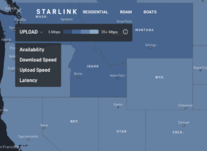
Starlink has satellite coverage in nearly all of North America, and even the open ocean (with the right plans). But that doesn't mean your internet access experience will be the same in all locations. Starlink's coverage map is a good place to start. For the US, Starlink's map has download, upload, and latency speeds by state.
You can get to this feature by clicking the drop-down menu next to the “Availability” icon.
Cautions
But be aware that obstructions and congestion can have a large influence on your connection. The speeds you get may not be as good as what is shown on the map if you're dealing with either of those things.
Carriers’ Cellular Coverage Maps
Each of the carriers publishes their coverage maps on their websites to make it easier for finding cellular signal. Unfortunately, some carrier coverage maps contain more helpful information than others.
Here's where each carrier keeps their maps:
- Verizon
- AT&T
- T-Mobile
- Boost Mobile (owned by Dish)
Cautions
Keep in mind, just because a carrier claims to have coverage - it doesn't necessarily mean you'll get it, or that it'll be usable signal. Nor do carrier maps promise a minimum data speed you can expect.
Many things can impact your signal - the gear you travel with, local terrain, weather, tower congestions, and more. Carrier maps are derived from computer modeling of the towers they have transmission gear installed on, and they don't usually account for those variables that can affect your signal.
Unfortunately, carrier maps can sometimes be a bit...umm...optimistic, as their maps are used for marketing purposes too.
But these coverage maps are still a good place to start: they will give you an idea of where your carrier claims to have signal available. If your carrier claims to have coverage in a certain area, then with the right gear, you probably can find a way to get online.
Coverage? App for Finding Cellular Signal
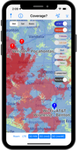
Although anyone can go to each carrier’s maps individually, we decided to make it easier by bringing the major carriers’ maps to your smartphone or tablet.
Want maps for Verizon, AT&T, T-Mobile, Verizon, and US Cellular in the US; and Rogers, Telus, and Bell in Canada?
We wrote an app for that!
Coverage? (available for iOS and Android) allows you to overlay regional or city-level resolution versions of the major carriers’ maps, created from Ookla's® cellular coverage data. This lets you create a personalized coverage map for the carriers you travel with. It even lets you choose the minimum coverage type (mmWave, mid-band, 5G Nationwide, LTE, and roaming) you seek.
The maps are stored on-device after downloading the app, so you don’t need to be online to find out which direction to head when you're looking for a signal.
Coverage? also features Ookla's SpeedTest®, allowing you to run tests that are shared with Ookla, improving the maps for the future, and giving users the opportunity to document performance at their favorite locations for future travels.
It’s also useful for planning your next RV or boat travel stop - you can look ahead to see if your carriers claim to have service in the areas you're planning to travel to.
Learn more about Coverage?- or download it from your app store:
Cautions
Do keep in mind, just because the carrier claims to have coverage, it doesn't mean you'll necessarily be able to get it. Many things can impact actual signal: like obstacles, distance to the tower, your modem, signal enhancing gear, and tower congestion.
FCC Cellular Coverage Map
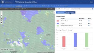
The FCC publishes its own National Broadband Map that shows both fixed and mobile broadband coverage. Crucially for our audience of nomads, it also shows "Outdoor Stationary" and "In Vehicle Mobile" cellular coverage. You can select carriers and cellular technology (4G/LTE, 5G Nationwide, 5G Mid-band, etc.). The map also shows what percentage of a cell has coverage when you hover a cursor over a cell (hexagon). As you zoom the map in, you get more and more refined information.
This map is relatively new and still a work in progress. The FCC is asking mobile users to download the FCC Speed Test app and submit results to help the FCC improve the map - and also help the FCC allocate federal resources for broadband.
As with the other maps, this official FCC map is not 100% accurate. Its baseline information comes from from carrier submitted data, and is only updated periodically.
But it can still be a useful, free tool in planning RV and boat travel around cellular mobile internet.
Crowdsourced Cellular Coverage Maps
There are resources out there that aggregate crowdsourced cellular signal and speed reports from other users.
Crowdsourced apps and websites use actual real-world user signal reports to build a coverage map for finding cellular signal and anticipated speeds. And then this information might be used by more advanced crowdsourced tools to geolocate where cell towers might be located.
These resources rely on user data, so to aid in collecting that data, they often utilize a smartphone app that measures signal on your device, and then reports that back to the database.
If you're interested in more detailed information about your planned locations - like signal strength and what towers are nearby - crowdsourced tools may help. They also provide information for locations beyond the US and Canada.
Here are the major (and free!) crowdsourced tools and apps:
- OpenSignal - http://www.opensignal.com
- Its main webpage is focused on their analyses of the data. You will need the cellular phone app to get to key planning tools like maps and speed tests.
- The App can be downloaded here: (https://www.opensignal.com/apps)
- Includes Speed-test Function
- Can track phone data usage
- Shows direction to the connected cell tower
- You can search for cellular tower information in other locations
- Allows you the option to share or not share your data
- Cellmapper - https://www.cellmapper.net/
- The App can be downloaded here: https://www.cellmapper.net/apps
- Its website allows access to nearby cell tower maps & data (the free version is ad-supported).
- Shows tower location information, tower signal sectors, supporting bands, MIMO, and several other tower characteristics.
- The App map can show which specific tower your device is connected to, assuming the tower is in the database.
- Option to manually upload collected data.
- Displays low-level cellular network information data along with frequency band calculations (for some providers and device dependent).
- The website can be confusing to use, but they do have a beta test with a simpler interface at https://www.cellmapper.net/testmap/.
- Has a monthly Premium membership option ($3 CAD) to get more features, including ad-free access.
- CoverageMap - https://coveragemap.com
- The App can be downloaded here: https://coveragemap.com/
- The website allows access to cell tower maps & data.
- It is a community-contributed map comparing coverage, data speeds, latency, and signal strength of all major cellular networks in the US.
- The free version, CoverageMap Basic, includes all maps, all filters, all map visualizations, maximum map resolution, and is ad-supported.
- The paid version, CoverageMap Pro, includes everything in Basic, plus leaderboard badge, exclusive discord role, access to beta features, free updates, and is ad-free. The price is $4.99/ month or $49.99/year.
Cautions
Of course, with crowdsourcing, the maps are only as useful as the data they collect from users of their apps.
These resources tend to have good data for urban areas where they have a strong user base. But, when you get to smaller cities, the maps can show no coverage at all (even when there is coverage!)
Also, it's important to note that these apps may not be representative of the actual signal or data performance you'll get in a location. The reports are based off of the gear used for collecting the data. The gear you have could give you better or worse results simply because of the modem specifications, external antennas or boosters you might have in your mobile internet arsenal.
For RVers and boaters planning travel beyond urban centers, it's wise to also supplement crowdsourced maps with the FCC or carriers' maps and campground/marina reviews for the best prediction of mobile internet connectivity.
Uber Geek Resources
One little-understood aspect of cellular networks is that carrier frequency licenses are not nationwide but vary by location. So even though a carrier may support a particular cellular band, they might not have a license to operate that band in every part of the country, or may only have access to parts of the band.
Spectrum Omega's Spectrum Ownership Map is a resource for uber-geeks who want to dig down to see who has licensed the spectrum in a particular area. This level of detail is of limited usefulness for travel planning, but may still be interesting and useful for those who understand the intricacies of cellular spectrum.
Campground/Marina Reviews
As many RVers and boaters depend on a solid internet connection, you’ll frequently find reports of cellular coverage, satellite aiming, and Wi-Fi performance hidden within campground reviews. Think of reviews as another resource for your RV and boat internet travel planning.
As a reminder, reports of "bars" don't equate to cellular data performance, and rapidly evolving cellular networks may make a 5-year old review not very helpful.
Likewise, tree coverage and other obstacles can vary widely across a campground, making satellite aiming challenges site-specific.
Here are some of our favorites:
RV & Camping Sites
- AllStays - Their app and website have reviews where past campers may have noted the cellular coverage. Download the App here: https://www.allstays.com/apps/
- Campendium – This review site includes specific fields for reporting the number of bars received from each of the major carriers in their reviews (reminder: bars don't necessarily equate to data performance). (Note: Campendium is now owned by Roadtrippers)
- Harvest Hosts - Their app provides a cellular coverage overlay on the map. You must be a Harvest Host All Access member to have access to this feature. Download the App here: https://www.harvesthosts.com/
- Recreation.gov - The booking platform for federally owned parks, such as National Forest campgrounds and Corps of Engineers parks. There is an area in their review section that shows camper-provided ratings of cell coverage for each carrier, which the service then conglomerates into an overall rating. Download the App here: https://www.recreation.gov/mobile-app
- Freecampsites.net – A database of remote camping and RV boondocking options. Reviewers are asked to report their cellular signal for each carrier, but you have to search individual reviews to get the information.
- RV Life Campgrounds – There is a Connectivity section for each park that indicates which carriers have service there, and also if the park provides Wi-Fi. There is a Connectivity filter when searching a general area, but you can only filter by Wi-Fi availability, not by cellular connectivity. RVers tend to leave coverage reports in their reviews. Their app allows users to report speed tests. (RV Life purchased the popular review site Campground Reviews, and reviews from that site are now incorporated into the RV Life review page.)
- RV Life Trip Wizard - Their routing tools include campground reviews with coverage reports, however it is a paid resource. Formerly known as just Trip Wizard, they are now owned by RV Life.
- RVParky – RVParky.com is a review site where you might find cellular coverage mentions within individual reviews, although they don't yet feature a filter feature for cellular coverage. You can filter by if a park offers free/paid Wi-Fi. It also has a paid membership RVParkyPro. Download the App here: https://www.rvparky.com/
- The Dyrt - A camping review website with a focus on tent camping, but inclusive of RV parks and campgrounds too. There are no specific areas to report cellular coverage or experience or search by it, but it might be mentioned in some reviews. Download the App Here: https://thedyrt.com/
Marina & Anchorage Sites
- ActiveCaptain - Boaters share their experiences on an app and website, and mentions of internet availability are often included within reviews. Download the App here: https://www.garmin.com/en-US/p/573254/
- Waterway Guide - Boaters share their experiences on the website, and mentions of internet availability are sometimes included within reviews. Download the App here: https://www.waterwayguide.com/mobile-app
Cautions
With crowdsourced reviews, the information is only as useful as the information being shared.
User submitted reports can have a lot of variability and could require you to parse through a lot of written text about a campground or marina. Details about a mobile internet connection could be hidden among reports on the bathhouse or playground.
Also, not everyone has the same mobile internet needs, therefore what is one camper's great experience may not be yours.
For instance, some may report in very general terms like 'I was able to work' or 'I was able to stream Netflix'. Or a review may report a solid connection if it was possible to check e-mail, but not mention video conferencing. And some may include what gear they have that made a connection possible, which can have a huge influence on performance.
Also keep in mind when the review was made, particularly for cell coverage - cellular technology is rapidly advancing and things can change in a matter of months in some locations.
And of course, don't just read reviews - leave your reviews to help your fellow travelers!
Starlink Travel Planning
 If you're a Starlink user and traveling to a new area, there are a few things to consider to make sure you can take full advantage of your Starlink service in your new location.
You'll need to consider how open your new area will be to the sky. Starlink needs a pretty much fully uninterrupted view of the northern sky to deliver great service and consistent reliable access. If you try to use your Dish anywhere where the sky is obstructed - by trees, or even neighboring boat masts, Starlink can struggle with dropouts. So you may want to choose a site with few obstructions, if that is an option.
You can research possible site obstructions in advance by using Google Maps satellite view, or perhaps even in some of the crowdsourced site reviews.
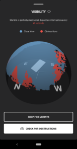
Starlink does provide an Obstruction Finder app for both iOS and Android that can be used to check to see how well Starlink might work for you in a given area. Unfortunately, the app can not be used in advance of your arrival at a location. But it can help you with choosing a site once you arrive and/or the best location for your Starlink Dish in your site.
It's also a good idea to check the weather in your new location before you arrive. Starlink is satellite based so it is still subject to possible weather interruptions. Heavy rain and hail seem to be the leading culprits for interruptions.
For more information on using Starlink, see our Starlink Resource Page.
Conclusion: Travel Planning is Essential for RV & Boat Internet
If it's important to you to know where along your RV or boat route you'll have a good internet, advanced travel planning is important. There are plenty of research tools available to help you, including carrier maps, our Coverage? app, crowdsourced apps, as well as online campground and marina reviews.
Unfortunately, there's not a one-stop-shop for knowing exactly what to expect at a particular location, but using several of these resources together can help.
This uncertainty and variability is why we consider REDUNDANCY to be the most essential tool in your mobile internet arsenal.
Learn More: The Importance of Mobile Internet Redundancy
Additional Reading
Starlink Guides
Starlink is constantly evolving its plans and its technology. We try to provide the latest information in our guides and resources:
Cellular Data Guides
Cellular data is a BIG topic, and there's a lot to understand to pick the right combination and gear, plans and signal enhancing options for your needs.
Check out some of these further resources we offer:
For More On Data Plans:
For more on selecting cellular data gear:
For more on getting the best cellular service:
Explore the Resource Center
Have Questions?
Join our 'Library Desk':
Internet for RVers & Cruisers Facebook Group
We cross post news articles and guides, and can help point you in the right direction to our content here on the resource center.
It is with gratitude to our premium members that we're able to offer our free content - and for that, they also have access to our member Q&A areas for more in-depth guidance.
Become a Member
 The MIA is our premium membership - designed for those who consider mobile internet an important part of their lifestyle.
In thanks for making content like this possible, we offer a bunch of additional perks. From interactive guidance, in-depth member exclusive content, discounts, alerts, classroom and ability to book private advising sessions.
Stay In the Know
We're constantly tracking the industry and analyzing new developments for mobile travelers. If you'd like to receive updates, we offer several ways:
- Subscribe to our free monthly newsletter
- Subscribe to our News Stories RSS Feed
- Subscribe to our YouTube Channel
- Follow our Facebook Page



 Mobile Internet Resource Center (dba Two Steps Beyond LLC) is founded by Chris & Cherie of